
Pt. 1 - Iceland 2018 - A Solo trip on the Ring Road
Thor’s Valley [Porsmork] - One of my favourite places in Iceland. Fuji X-H1 + 16mm 1.4 lens
This is part 1 of a 3 part series of very, very long blogs on my 2018 solo trip to Iceland, I’m going to be keeping these posts photo heavy with a focus on locations and tips for visiting Iceland as well as a bit of camera stuff too.
I took this trip in July 2018, 2 weeks, just myself and a car for company, I was camping as I went and the main goal was driving the 828 mile ring road which circles the country, stopping to visit the many, many wonderful sights Iceland has to offer along the way.
This first part is on the famous Golden Circle, the South coast and the not so well known Thor’s Valley, if you have any questions then drop me a line on Instagram: @colinnichollsphotography
Welcome to Iceland…


pt. 1 - THE GOLDEN CIRCLE, SOUTH COAST + THOR’S VALLEY
The plan for the first few days was to make my way East on the ring road, I was blessed with incredible weather following the ‘worst summer for 100 years’ in Iceland, so I made the most of this and got up early and went to bed late.
It never really gets dark this time of year in Iceland, so if you’re savvy you can wake up super early, miss the first tour buses of the day and you get the most incredible light, win-win.

Obligatory airplane window photo.

On hiring a car in Iceland.
Iceland is expensive, any by far the highest expense on this trip was my car, a brand new Dacia Duster 4x4. I’d strongly recommend a 4x4, also get ALL of the insurance [volcanic ash insurance sounds farfetched till it strips the paint off your hire car] - Also don’t drive in water, no insurance will cover water damage.
[On and stick to the roads, driving off road is illegal in Iceland]
DAY 1.
I landed at Keflavik airport first thing in the morning, after picking up my hire car I hit the road straight away and drove to the south side of the Reykjanes peninsula, this area is a geothermal hotspot and less visited than other tours such as the golden circle.
This map marks Krysuvik [Also called Sultun], where possible I’ll be putting co-ordinates on my descriptions of the locations so they can easily be found. A lot of these things are off the beaten path [hence why a 4x4 is ideal].
![Indjánahöfði - [63.9543992,-21.881427] Fuji X-H1 + 23mm 1.4 lens](https://images.squarespace-cdn.com/content/v1/5229b80ee4b0dbbcb4a83168/1548336772140-H587L4NEQ26NV5HJQ53C/pano-2.jpg)
Indjánahöfði - [63.9543992,-21.881427] Fuji X-H1 + 23mm 1.4 lens
Indjánahöfði + Kleifarvatn Lake
This cliff looks over the largest lake in the Reykjanes Peninsula, which interestingly has no visible water coming in or going out, most of it’s water comes and leaves from underground. At it’s deepest it’s 97m and since a series of earthquakes in 2000 the lake has lost 20% of it’s surface area, most likely due to fissures opening up at the bottom of the lake and draining the water.
Legend has it that a monster in the shape of a worm but the size a whale lives in the lake. I didn’t see it.
TIP, you can park at the top to great a great look over the lake, approach form the south if you’re in a small car as the road north isn’t paved, yet.
![Krysuvik - [63.8950935,-22.0538981] Fuji X-H1 + 16mm 1.4 lens](https://images.squarespace-cdn.com/content/v1/5229b80ee4b0dbbcb4a83168/1548337247782-1KHW1QXO7V6Q8OFY8L6G/krysavik-4.jpg)
Krysuvik - [63.8950935,-22.0538981] Fuji X-H1 + 16mm 1.4 lens
Krysuvik
This geothermal area is just up the road from the nearby Kleifarvatn Lake. In amongst multi coloured hills is an expanse of steam vents, bubbling mud pools and hot springs that sit in the middle of a fissure on the Mid-Atlantic Ridge, the whole area smells strongly of sulphur and the acrid stench hits the back of your throat as soon as you open the car door.
This place is easy to get to with decent parking, but if you’re in a small car approach from the south, the north road is not paved.


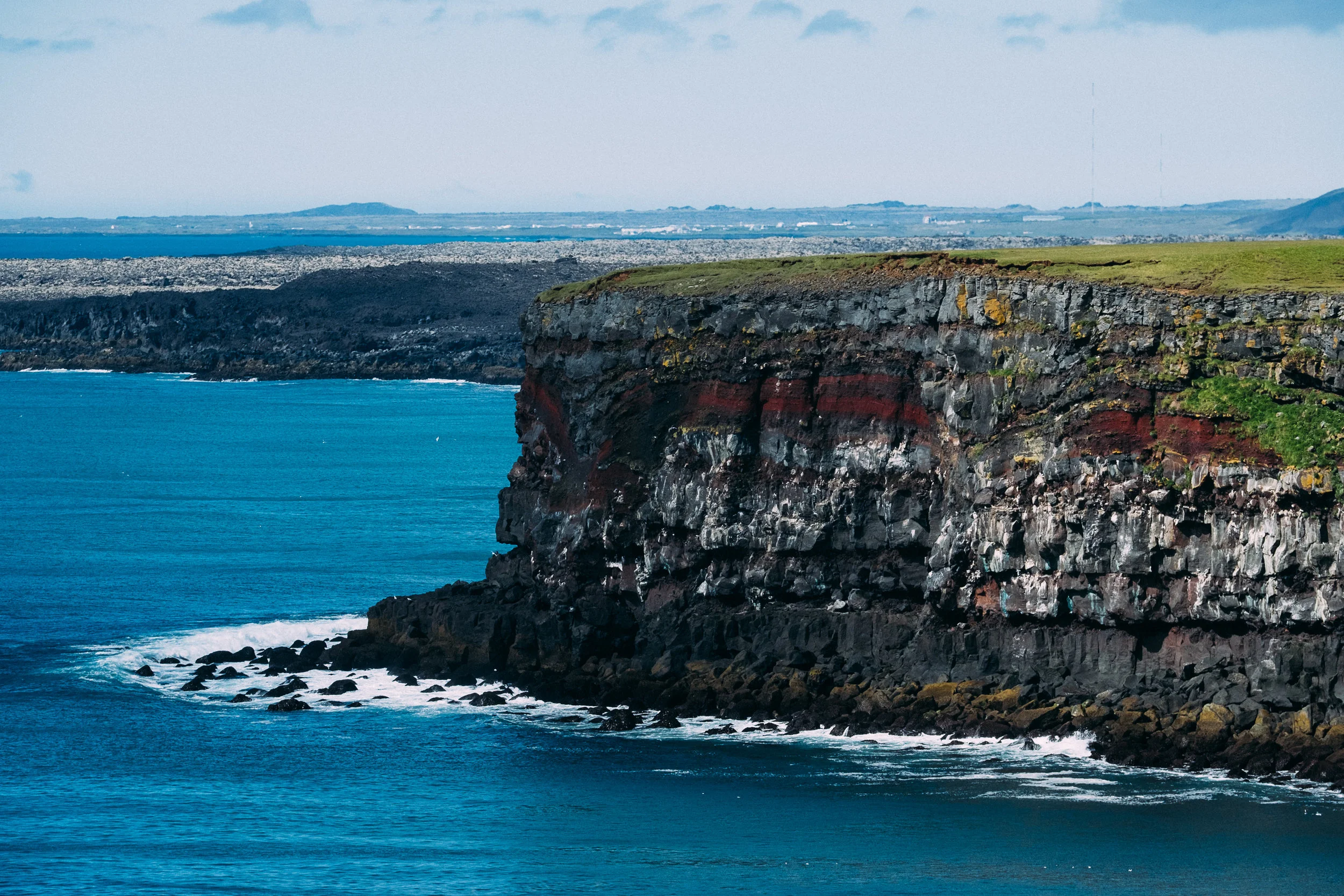
![Krisuvikurberg Cliffs - [63.8284791,-22.1115541] Fuji X-H1 + 16mm 1.4 lens](https://images.squarespace-cdn.com/content/v1/5229b80ee4b0dbbcb4a83168/1548337654109-UNXWTGY0W005Z554P0J4/iceland-1.jpg)
Krisuvikurberg Cliffs - [63.8284791,-22.1115541] Fuji X-H1 + 16mm 1.4 lens
Krisuvikurberg Cliffs
Iceland is well known for it’s bird colonies and the sheer cliff faces of Krisuvikurberg are the perfect nesting ground for over 60,000 birds including puffins. The cliffs with their distinctive red stripes rise up 40 meters from the oceans surface are a bit of a bumpy drive [4x4 for the win] but when there you are rewarded with quite the epic view.
The road to get here is rough, bumpy and not suitable for small cars, there’s also a sketchy as hell cattle grid that’s falling apart.

![Arnarker Cave - [63.8709682,-21.5420446] Fuji X-H1 + 16mm 1.4 lens](https://images.squarespace-cdn.com/content/v1/5229b80ee4b0dbbcb4a83168/1548338230783-AWHKS6LY4BKW0LKTB2E9/arnarker-3.jpg)
Arnarker Cave - [63.8709682,-21.5420446] Fuji X-H1 + 16mm 1.4 lens
Arnarker Cave
Heading East and onto the 380 road is the Arnarker cave in the Leitarhraun lave field, for which you have to climb a ladder to get into. This unassuming entrance leads into the dark, wet cave, for which you need a headlamp, decent shoes and ideally a helmet and proper gear to venture further in, I didn’t have all this stuff so settled for a peak inside this hidden gem of a place.
THIS IS SUPER HARD TO FIND. The road towards its says it’s closed [it’s not] keep driving for about 5 minutes then look on google maps for a large black spot, thats the cave, there are no signs.


![Kerid Crater - [64.1076371,-20.9471584] Fuji X-H1 + 16mm 1.4 lens](https://images.squarespace-cdn.com/content/v1/5229b80ee4b0dbbcb4a83168/1548338678127-EYBPT7K1GNBDOGBQ6KWR/kerid-1.jpg)
Kerid Crater - [64.1076371,-20.9471584] Fuji X-H1 + 16mm 1.4 lens
Kerid Crater
Lakes in craters are a pretty common sight in the volcanic landscape of Iceland but Kerid stands out, its caldera [A caldera is when the volcano collapses in on itself to make a crater] is 55m deep and 270m across and is made up of less common red volcanic rock. It is 3000 years old which makes in young in comparison to the other volcanic features nearby and is home to a shallow lake at the bottom which, due to minerals from the soil takes on the striking green-blue colour.
The landowners charge 400ISK [About £3] for admission, it gets busy here with lots of tours and visitors.


![Bruarfoss Waterfall - [64.25061,-20.5344794] Fuji X-H1 + 16mm 1.4 lens](https://images.squarespace-cdn.com/content/v1/5229b80ee4b0dbbcb4a83168/1548338898329-TNR230OAH17OGBY7BV48/icland-2.jpg)
Bruarfoss Waterfall - [64.25061,-20.5344794] Fuji X-H1 + 16mm 1.4 lens
Bruarfoss Waterfall
Heading North towards the highlights of the well known ‘Golden Circle’ tour is the slightly hidden milky blue waterfall of Bruarfoss [Bridge Falls] It’s not it’s size that makes this waterfall impressive instead its bright blue centre which is formed when the river enters a deep crevice of volcanic rock formations thus concentrating it’s blue colour.
REALLY HARD TO VISIT. The waterfall is in a private summer house community, which is gated, to get here you will either have to walk from the North, or as I did, get lucky and find the barrier up, drive in and park somewhere discreet.


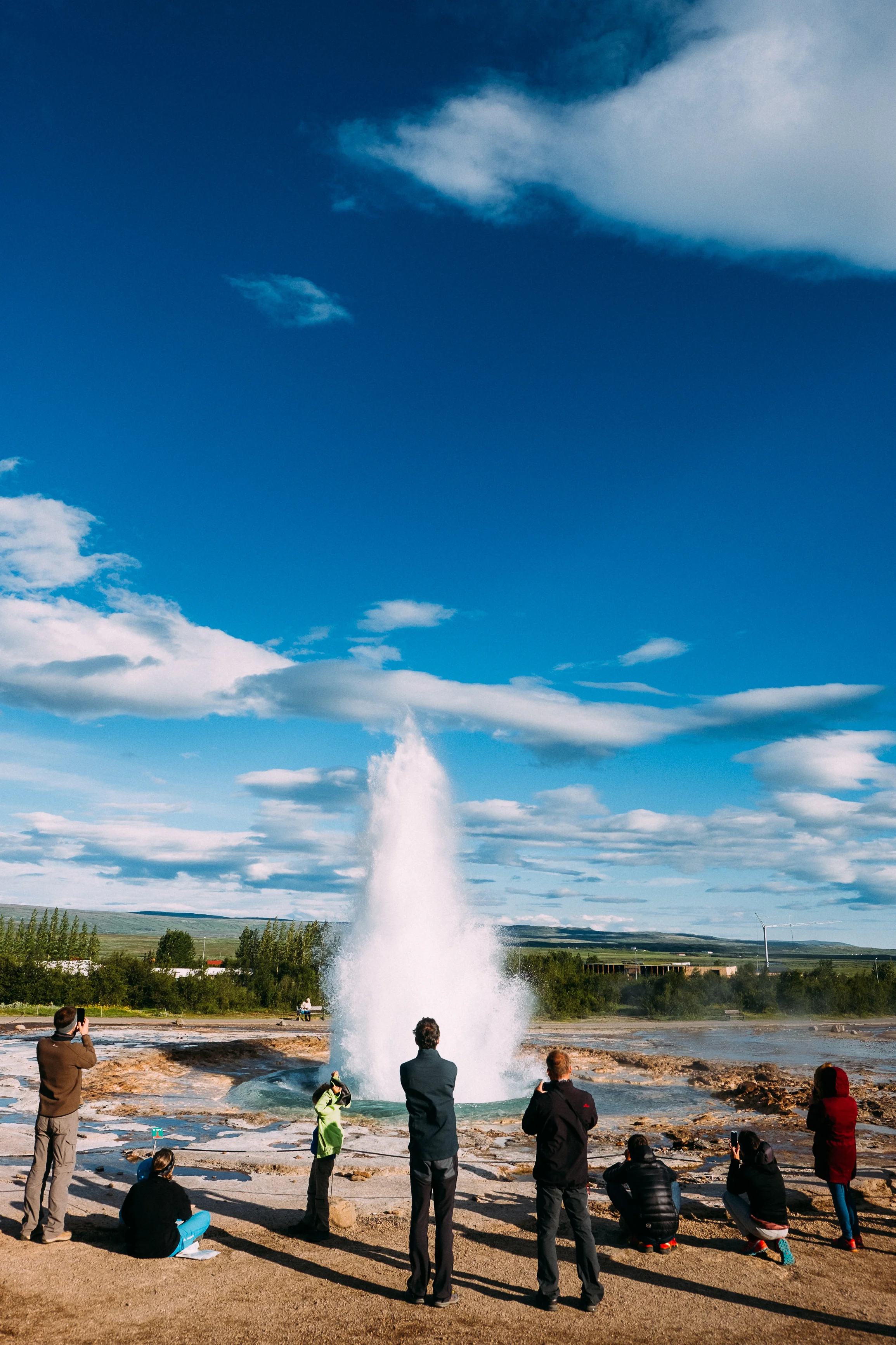
![Geysir Park - [64.3065807,-20.3225138] Fuji X-H1 + 16mm 1.4 lens](https://images.squarespace-cdn.com/content/v1/5229b80ee4b0dbbcb4a83168/1548339463967-AR2L95AHKW1GXOF3RIRM/icland-3-2.jpg)
Geysir Park - [64.3065807,-20.3225138] Fuji X-H1 + 16mm 1.4 lens
Geysir Park
Carrying on up road 35 and you get to the well known Geyser park, home to the regularly firing Strokkur which bubbles up, bulges out and shoots water up to 20m in the air.
The rest of the park is home to hot water pools, bubbling mud pits and boiling streams, there are countless signs telling you to not touch the water because it’s hot, which is also where you can see countless numbers of people touching the water to see just how hot it is.
Across the road is a shop selling all sorts of Icelandic stuff, wool things and trinkets are in abundance.
BUSY. This is one of the highlights of short tours in Iceland and it gets very busy, there’s decent parking; early morning, ahead of the bus tours is the best time to visit.


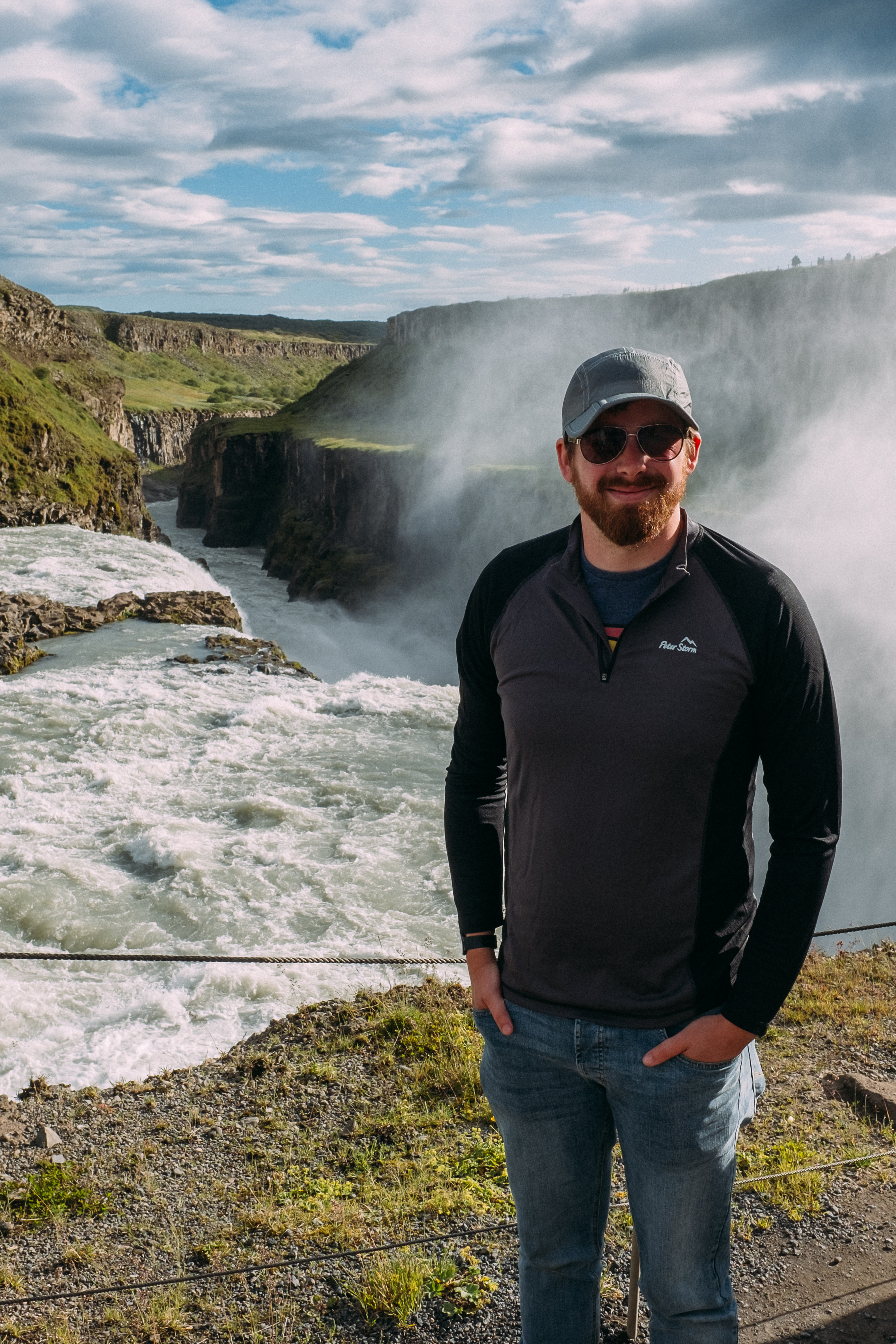
![Gullfoss - [64.3241857,-20.1315201] Fuji X-H1 + 16mm 1.4 lens](https://images.squarespace-cdn.com/content/v1/5229b80ee4b0dbbcb4a83168/1548339833451-WDVJ8C2E5NOE1YYNE6Y5/gullfoss-1.jpg)
Gullfoss - [64.3241857,-20.1315201] Fuji X-H1 + 16mm 1.4 lens
Gullfoss
The river Hvita falls down two stages of 11m and 21m to make up the ‘Golden Falls’ a mighty impressive sight and one of Iceland’s most famous attractions.
You can view the falls from the top and also walk down to get close to the falls in the canyon. [You can only view from the top in the winter]
During the late 20th century the area was going to be used to harness hydroelectric power but Sigrid Tómasdóttir led a campaign to save the waterfall and a stone memorial to her sits above the falls.
BUSY. This is one of the highlights of short tours in Iceland and it gets very busy, there’s decent parking; early morning, ahead of the bus tours is the best time to visit.


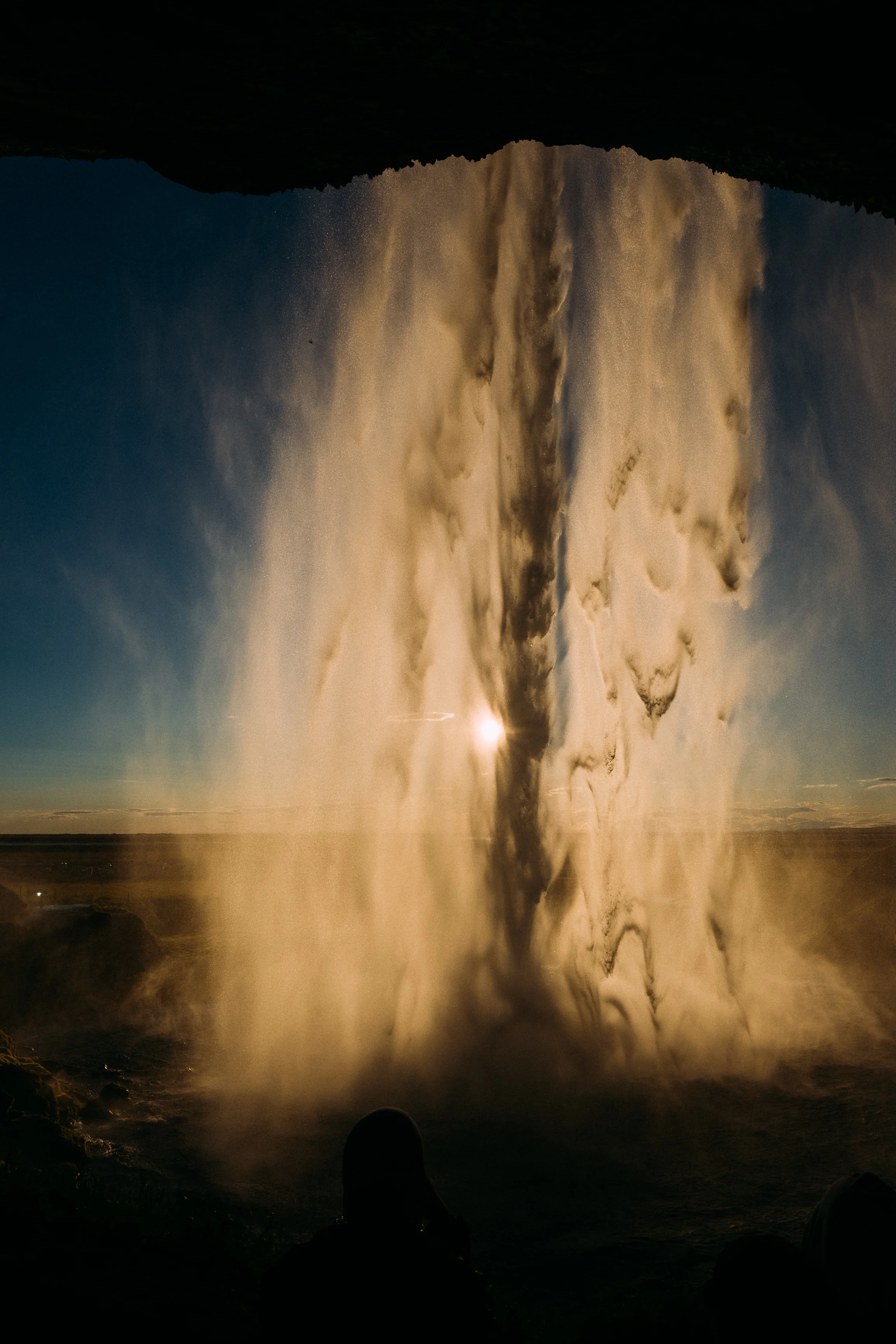
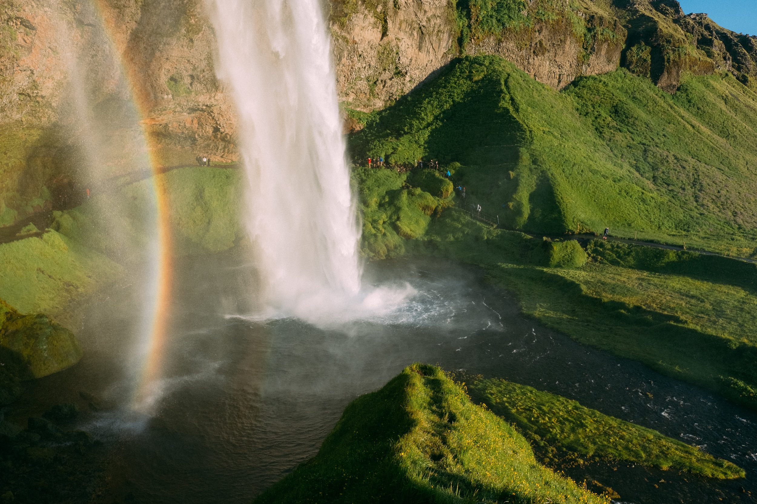
![Seljalandsfoss - [63.6156188,-20.0586104] Fuji X-H1 + 16mm 1.4 lens](https://images.squarespace-cdn.com/content/v1/5229b80ee4b0dbbcb4a83168/1548340267224-2JZJN7DRW6V7NT39DH3U/seljalandfoss-1.jpg)
Seljalandsfoss - [63.6156188,-20.0586104] Fuji X-H1 + 16mm 1.4 lens
Seljalandsfoss
Another of Icelands famous waterfalls, this mighty 65m tall is thrown over a cliff which allows you to walk behind it, it is well visited and for good reason this spot is just beautiful.
As you drive closer you can see it from the road and it’s only when you are near it and can see other people that you get a true sense of it’s massive scale.
You’ll have to pay to park 750ISK [About £6] It gets very, very busy here. The nearby campsite is ideal if you are staying the night.


The campsite near Seljalandsfoss
That was the end of day one, the above photos are taken at about 11.30pm, and that golden light lasted for ages, I ended up driving much more than I had planned, but as the light was so good it was too tempting not to.
I also stopped by a supermarket [BONUS is best] to stock up on supplies, as well as getting more fuel and a couple of epically overpriced beers.
Driving Tips;
Fill up on fuel when you get to a half tank, you don’t want to gat caught out
The speed limit is 90km [55mph] there are police and they will stop you
Drive with your lights on at all times, it’s the law
Watch out for horses on the road
Don’t drive off road, it’s illegal
All fuel is pay before you pump, using a credit card is easy and instructions are in multiple languages
All petrol stations sell camping gas canisters [but check the left over box at campsite to sometimes get some for free]


The above map marks the location of Seljavallalaug, with Seljalandsfoss to the West and Vik to the East
DAY 2.
I got up early, mainly because I was freezing cold, evening the summer it’s about 3 degrees in the night, as such I took today to buy a very nice [also very expensive] Icelandic woollen blanket, which helped me sleep so darn much [more camping and sleeping tips at the end of day 2]
I headed along the ring road east, but I would be coming back this way as in the afternoon I was getting a bus into Porsmork, I also left my car at the campsite after paying for an extra night so I knew it would be somewhere safe.
Onwards to day 2…
![Seljavallalaug Swimming Pool - [63.5939412,-19.7833169] Fuji X-H1 + 16mm 1.4 lens](https://images.squarespace-cdn.com/content/v1/5229b80ee4b0dbbcb4a83168/1548341555619-X6IHQAJIVWVETXXGSES9/sellavalllaung-4.jpg)
Seljavallalaug Swimming Pool - [63.5939412,-19.7833169] Fuji X-H1 + 16mm 1.4 lens
Seljavallalaug Swimming Pool
I made an early start after a freezing cold and sleepless night and headed for this little south Iceland secret swimming pool.
Built in the 1920’s it is one of the oldest geothermal swimming pools in Iceland, 10m wide and 25m long it sits at the foot of a mountain. The pool was built to teach Icelanders to swim as most of them worked on fishing boats and even today all Icelanders must pass a swimming test before graduating school.
TIP. This place isn’t visited by any bus tours [yet] it’s free to use with changing rooms on site, if you’re early you can get it all to yourself.


After Seljavallalaug I picked up a couple of hitchhikers, these guys came with me to the next few places…
![Skogafoss - [63.5563556,-19.6569742] Fuji X-H1 + 16mm 1.4 lens](https://images.squarespace-cdn.com/content/v1/5229b80ee4b0dbbcb4a83168/1548342266912-RLD2FP0P1FTTLZ2FNY5E/iceland-4.jpg)
Skogafoss - [63.5563556,-19.6569742] Fuji X-H1 + 16mm 1.4 lens
Skogafoss
A little ways down the road after my dip in a hidden pool is the huge and imposing Skogafoss waterfall, the falls sit of the cliff of a former coastline [which is now about 5km to the south], it is 15m wide and drops an impressive 60m in an almost perfect shape.
The legend is that the first Viking settler in the area, Þrasi Þórólfsson, buried a treasure chest in a cave behind the waterfall, years later locals found the chest but could only grasp at the ring on the side of the chest before it disappeared. The ring was given to the local church and now can be seen in the Skogar folk museum nearby.
Be sure to go up the steps to see it from the top, then carry on through the gate to see another waterfall just behind.
TIP. Busy, busy place, but well worth the visit, wandering off the marked paths is now forbidden.


![Kvernufoss - [63.528319, -19.480608] Fuji X-H1 + 16mm 1.4 lens](https://images.squarespace-cdn.com/content/v1/5229b80ee4b0dbbcb4a83168/1548342863589-MLYZUHRG7ECCL7ZG5O80/iceland-1-4.jpg)
Kvernufoss - [63.528319, -19.480608] Fuji X-H1 + 16mm 1.4 lens
Kvernufoss
I spent an age looking for information on this waterfall, Instagram and 500px had plenty of this falls which you can walk behind but no one was saying what it was called or where it was.
It’s a short walk from Skogar down a little gorge and you are met by this 30 meter secret waterfall, you won’t be able to see this on bus tours and it is becoming more well known so don’t expect to have it to yourself.
TIP. Hard to find, head behind the Skogar Folk Museum and across the field.


![Gljufrabui - [63.5917038,-20.0197858] Fuji X-H1 + 16mm 1.4 lens](https://images.squarespace-cdn.com/content/v1/5229b80ee4b0dbbcb4a83168/1548343295095-LWP0DXGJENJ2DKQR2GUU/iceland-1-7.jpg)
Gljufrabui - [63.5917038,-20.0197858] Fuji X-H1 + 16mm 1.4 lens
Gljufrabui
A short walk from Seljalandsfoss is the under-visited Gljufrabui, a 40 meter high waterfall in a gorge [The name means ‘dweller in the gorge’] and is partially covered by large rock formations, as you go through the crack into the rock you can walk right into the waterfall.
TIP. You will get wet. Very wet. If the water flow is high you’ll have to either use the stepping stones or get your feet wet, when inside the spray will soak you. Getting out while people get in is hard, so visit when it’s quiet [early morning, late night]


![Porsmork [Thor’s Valley] This is the view from Valahnjúkur - [63.7122545,-19.5432259] Fuji X-H1 + 16mm 1.4 lens](https://images.squarespace-cdn.com/content/v1/5229b80ee4b0dbbcb4a83168/1548344252019-P8DWGG6KO8XS43A59QC4/iceland-6.jpg)
Porsmork [Thor’s Valley] This is the view from Valahnjúkur - [63.7122545,-19.5432259] Fuji X-H1 + 16mm 1.4 lens
Porsmork
‘Thors Valley’ is aptly named after this Norse god, and is the real start of the Icelandic wilderness. I chose to not drive to this location, mainly due to the 15+ river crossings and not wanting to get stuck in a river, as such I took the 4x4 bus which charges through the rivers with no problem.
I rode from Seljalandsfoss to Langidalur, which is a camping hut nestled in a valley and is just the most stunning location, the Eylafjallajökull volcano rises into the sky towards the south.
TIP. The bus comes all the way from Reykjavik, but you can get it some Seljalandsfoss [just wave it down] you can camp at the last stop, but bring food.
IMPORTANT TIP. You can’t drive a normal 4x4 here, the last river is deep and fast, you need a special car and experience, get the bus.


![This is the view from Valahnjúkur - [63.6838094,-19.5338247] Fuji X-H1 + 16mm 1.4 lens](https://images.squarespace-cdn.com/content/v1/5229b80ee4b0dbbcb4a83168/1548344596194-YIFA6ZA9JEUWI229VCYA/iceland-5-2.jpg)
This is the view from Valahnjúkur - [63.6838094,-19.5338247] Fuji X-H1 + 16mm 1.4 lens
Valahnjúkur
This place.
It sounds epic just from the name and a relatively short hike from the Langidalur camping huts puts you at one of the best spots in the area for taking it all in. The views are just incredible and down below you in the valley a host of rivers meet and mingle and lead off into the distance. I went up twice, once at 1am [when the above photo was taken] and again in the morning.
This is truly a wonderful place.
TIP. There are signs from the campsite, it’s an easy hill walk, there are many other hiking trails nearby.


The Langidalur camping huts, this is where the bus stops and turns around.
Day 2 was incredible, another long day but the constant light helps with being tired, walking up mountains at 1am is amazing, and getting the bus to Porsmork was well worth it.
I settled down in the tent for the night before catching the bus back to my car in the morning.
Camping Tips.
WILD CAMPING IS ILLEGAL, anywhere, the only excuse is for legit hikers or mountaineers, there are loads of campsites all over the place
It’s cold, get a 4 season sleeping bag and an additional blanket
Ear plugs for noise
Eye mask for light
Get a tent that’s quick to put up and take down
Most campsites are pay before you setup, find the office before going in
Camping ranges from 1000ISK - 2000ISK for a night [about £10-20]


The above map marks Dyrhólaey
DAY 3.
After a slightly better nights sleep I got the bus out of Porkmork, back to the car and hit the road going East, it took a while of waiting for a bus so this was a shorter day ending up at the small town of Vik.
Day 3…
![Sólheimajökull Glacier - [63.5954298,-19.6417821] DJI Mavic Air Drone](https://images.squarespace-cdn.com/content/v1/5229b80ee4b0dbbcb4a83168/1548345358260-DH0LYRE5UPPK56M109YN/iceland-1-9.jpg)
Sólheimajökull Glacier - [63.5954298,-19.6417821] DJI Mavic Air Drone
Sólheimajökull Glacier
A little ways down road one and you can take a side road [used to be a track but it’s paved now] and you can get to the foot of the Sólheimajökull glacier.
A Short walk takes you to the constantly melting and changing ice landscape where 10,000 year old ice is exposed to the air for the first time before flowing out to the sea. This all forms part of the Mýrdalsjökull ice cap under which lies the Katla volcano, which, when it erupts will cause utter devastation as the ice melts into biblical flash floods and pumice and ash rain from the sky.
The glacier recedes at a pace of 100m per year [see the photo below] and so is always changing, at its thickest the Mýrdalsjökull ice cap is 700m thick.
DO NOT walk on the glacier without proper gear and a guide, it’s slippy, there are holes everywhere and the ice can break at anytime. [You can book guided tours from the nearby hut]


![Dyrhólaey - [63.4185394,-19.1676534] Fuji X-H1 + 16mm 1.4 lens](https://images.squarespace-cdn.com/content/v1/5229b80ee4b0dbbcb4a83168/1548346160223-8HUAH6Q8Y3I1XFJ4A82J/iceland-1-10.jpg)
Dyrhólaey - [63.4185394,-19.1676534] Fuji X-H1 + 16mm 1.4 lens
Dyrhólaey
Almost of far south as you can get on the main land is Dyrhólaey from which you can see great views of the black sand beaches and of course the wonderful rock formation itself. The cliffs here are home to seabirds which means there is limited access by car at certain times of the year, the drive up is very, very steep.
It was the first day of not so good weather, but the views are still stunning, I headed to Vik after this to setup camp for the night.
TIP, the cave in the photos below is on the road to Dyrhólaey but it’s not signposted, just keep an eye out on your left and pull up into a little parking spot.


![Cave near Dyrhólaey, you can park where you see my silver car, watch out for nesting birds which will dive bomb you. - Fuji X-H1 + 16mm 1.4 lens [panoramic composite]](https://images.squarespace-cdn.com/content/v1/5229b80ee4b0dbbcb4a83168/1548346261605-LO7LL76DZPEF75B4N5PY/iceland.jpg)
Cave near Dyrhólaey, you can park where you see my silver car, watch out for nesting birds which will dive bomb you. - Fuji X-H1 + 16mm 1.4 lens [panoramic composite]
![Reynisfjara Beach - [63.405232,-19.0493241] Fuji X-H1 + 16mm 1.4 lens](https://images.squarespace-cdn.com/content/v1/5229b80ee4b0dbbcb4a83168/1548346732014-4ROJENNK9ZO33Q246WZ8/iceland-2-8.jpg)
Reynisfjara Beach - [63.405232,-19.0493241] Fuji X-H1 + 16mm 1.4 lens
Reynisfjara Beach + Sea Stacks
Just down the road from Vik is Reynisfjara Beach, another black sand beach with leads to the most incredible basalt column cave, surrounded by a fierce ocean which is advised you don’t go near and you never turn your back on.
Out in the ocean are several giant sea stacks, the Reynisdrangar, which legend has it were trolls trying to pull ships from the ocean before the dawn rose turning them all to stone. They are in fact the cores of long dead volcanos.
DON’T go near the sea, or turn your back on it, sneaker waves are common and will wash the beach and you back into the cold unforgiving ocean.

The Reynisdrangar - Fuji X-H1 + 16mm 1.4 lens
That’s it for the third day, relatively short, but also it was nice to get setup at camp and relax for the night, Vik has a very good campsite and is in an ideal spot to stop, it also has a gas station and is well worth filling up here before taking the long road east.
The above map marks Hjörleifshöfði, as you look south head to the left around the rock to find the cave.
DAY 4.
I left Vik early morning and got ahead of the bus tours and other people, once you get past Vik there are fewer bus tours and the sights are a bit more chilled out, I was also able to get get the drone up a bit more.
Enjoy day 4…
![Gigagja Cave, it looks like YODA! [63.4176393,-18.8333404] Fuji X-H1 + 16mm 1.4 lens](https://images.squarespace-cdn.com/content/v1/5229b80ee4b0dbbcb4a83168/1548347070483-4KJGCZM0B43RF4GBIGOI/iceland-2-9.jpg)
Gigagja Cave, it looks like YODA! [63.4176393,-18.8333404] Fuji X-H1 + 16mm 1.4 lens
Hjörleifshöfði
A little ways up the road from Vik is Hjörleifshöfði, 221 meters high and named after the viking settler Hjörleifur Hróðmarsson, who’s burial mound sits on top of the hill alongside the plot of some former inhabitants of Hjörleifshöfði.
There are several pillars of rock around here, as well as a cave, Gigagja, about 20 meters high and with two openings making a bridge at the entrance of the cave.
To get here it’s a little drive down a track which is a road even if it doesn’t look like it.
Miles of quiet, an ideal place to fly.
A Note on Drones.
Iceland’s drone rules are rapidly changing, most of the main attractions forbid them and getting caught can land you with a hefty fine. There are also a lot of other people with them so look out for who else is around flying.
Look out for signs of where you can and can’t use them, in particular never use them near bird colonies.
![Laufskálavarða - [63.5052101,-18.7835507] Fuji X-H1 + 16mm 1.4 lens](https://images.squarespace-cdn.com/content/v1/5229b80ee4b0dbbcb4a83168/1548347520871-GG91UMP5CADNXBXHV8FL/iceland-1-13.jpg)
Laufskálavarða - [63.5052101,-18.7835507] Fuji X-H1 + 16mm 1.4 lens
Laufskálavarða
Icelanders have made stone cairns for centuries, used as markers and guide posts for people on their travels they can be seen all over Iceland. And this spot has hundreds, all left by past travellers for good luck on their journeys, however building them now is forbidden.
This is an ideal road stop with toilets. [Along the road east you won’t find many gas stations or toilets, some rest stops have porta-loo’s, be sure to take advantage]
PLEASE don’t build you own stone towers, it’s illegal and they will just get knocked down.
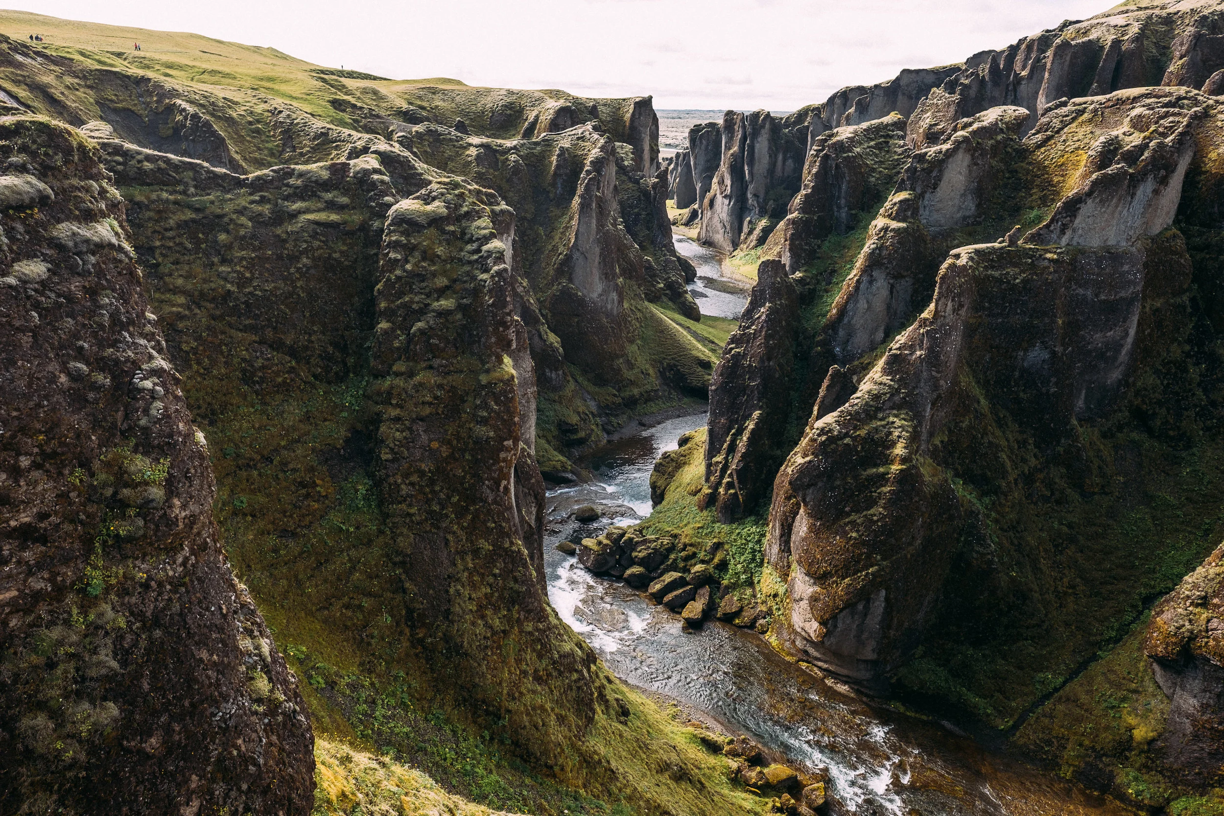
![Fjaðrárgljúfur - [63.6736749,-18.4691622] DJI Mavic Air Drone](https://images.squarespace-cdn.com/content/v1/5229b80ee4b0dbbcb4a83168/1548348010615-KEB0J2L59AM0V2Z50CYM/iceland-1-14.jpg)
Fjaðrárgljúfur - [63.6736749,-18.4691622] DJI Mavic Air Drone
Fjaðrárgljúfur
100m deep and 2km long this canyon looks like it’s been carved out by the gods themselves. You can only walk along the top along the paths [straying off them is forbidden and somewhat dangerous], walking in the canyon itself is no longer allowed.
And the end of the path is a large waterfall and you get a great view back down the canyon.
TIP, parking is very limited and tight here.

![Stjórnarfoss Waterfall - You can park across the road and walk over - [63.7826229,-18.1233331] DJI Mavic Air Drone](https://images.squarespace-cdn.com/content/v1/5229b80ee4b0dbbcb4a83168/1548348532438-THN7KOW2C6KM9AB6TJTW/iceland-2-12.jpg)
Stjórnarfoss Waterfall - You can park across the road and walk over - [63.7826229,-18.1233331] DJI Mavic Air Drone
Kirkjubæjarklaustur, Kirkjugólf & Stjórnarfoss Waterfall
A small village with a lake that sits above it with the Systrafoss waterfall, and round the corner the Stjórnarfoss waterfall, and some interesting history. This is where the convent was that housed the sinner sister nuns.
Nearby a hilly mound, Hildishaugur, is the burial place of a pagan man, who after being told that the village was enchanted and that pagans were unwelcome decided to move their anyway. He fell down dead as soon as he set foot in the estate.
‘The Church Floor’, Kirkjugólf is an expanse of basalt columns buried in the ground, columnar basalt is formed when lava cools and contracts, cracks then form horizontally and results in this formation.
TIP, Kirkjubæjarklaustur [the villiage] is a good place to stop for fuel.


![Lomagnupur - [63.8779448,-17.9493699] DJI Mavic Air Drone](https://images.squarespace-cdn.com/content/v1/5229b80ee4b0dbbcb4a83168/1548349748289-GW0B81UO1PT7E9YY279R/iceland-1-16.jpg)
Lomagnupur - [63.8779448,-17.9493699] DJI Mavic Air Drone
Lomagnupur + The Long Road
Rising out of the ground like an anvil of the gods is the 764m high mountain of Lomagnupur.
The folktale goes: The chieftain Flosi Þorgeirsson had a dream he was by the mountain, which then opened up and a giant appeared who called out his and the names of his men. He then slept, called out more names, Flosi asked him what his name was and he replied Járngrimur. Flosi’s analysis of the dream was that all then mens who’s names were call out were going to be killed.
On the way towards the East you drive through the biggest lava field in Iceland [this is years old solid lava, liquid lava is a lava flow].
In 1783 for 8 months the Lakagígar craters violently erupted, putting out an estimated 42 billion tons of lava as well as clouds of poisonous hydrofluoric acid and sulfur dioxide. This killed 50% of the Icelandic livestock as well as crops, destroyed 20 villages, and the resulting famine killed 25% of the human population.
ON BRIDGES; pretty much every bridge from here on out is a single lane bridge, with priority given to whoever is on it first, the one above has passing place but do be carful. At the time of writing this a family recently lost their lives on this bridge, please take care on the roads.


That was day 4, another stunning day, I ended the day at the campsite near Svartifoss, it’s a rather busy one but with good showers.
By now my sleep pattern was adjusting to the light, the best approach is to get up and go as soon as you are awake and nap in the day if you need to, also a couple of beers are always good at getting your head down in the evening.
The map above marks Svartifoss.
DAY 5.
I visited the nearby Svartifoss waterfall and took a guided tour today before hitting the road, this part of the trip was a bit of back and forth but it’s an area well worth exploring
Day 5….
![Svartifoss - [63.9881054,-17.2526969] Fuji X-H1 + 16mm 1.4 lens](https://images.squarespace-cdn.com/content/v1/5229b80ee4b0dbbcb4a83168/1548350615119-1CQ74VHT2X60C8VSHF2W/iceland-1-17.jpg)
Svartifoss - [63.9881054,-17.2526969] Fuji X-H1 + 16mm 1.4 lens
Svartifoss
One of the most majestic of all Iceland’s waterfalls, this 20m waterfall flows over basalt columns is about an hours walk to get to, with stunning viewpoints along the way. The name means ‘Black Falls’ and along the path there are several other waterfalls that all sit at the foot of the Vatnajökull glacier, one of the largest in Europe.
TIP, you can walk to this falls from the campsite, it’s a fairly long walk with a few steep bits, but generally easy going for most people.
TIP 2, you can only get as close as the photo above, new railings stop you from going closer.


![Falljökull Glacier Tongue - [63.9763882,-16.7787548] Fuji X-H1 + 23mm 1.4 lens](https://images.squarespace-cdn.com/content/v1/5229b80ee4b0dbbcb4a83168/1548351065635-1U9MXIDAFCSN0YJR8MJV/iceland-1-21.jpg)
Falljökull Glacier Tongue - [63.9763882,-16.7787548] Fuji X-H1 + 23mm 1.4 lens
Falljökull Glacier Tongue
On the first of a few guided tours and days out was an Ice walk on the Falljökull glacier, crampons on and go pro strapped to my chest we headed up to the ice. Similar to the first glacier tongue I visited on the South coast but I was really glad to be able to walk up and on to one.
The ice here carries small deposits of volcanic ash and sand, which when it melts leaves behind giant rolling slopes and cones of black powder.
TIP, take a guided tour, these are dangerous places and the tours are great and very informative.


A stunning campsite near the Svartifoss waterfall.
![Jokulsarlon - [64.002882,-16.2114047] Fuji X-H1 + 23mm 1.4 lens](https://images.squarespace-cdn.com/content/v1/5229b80ee4b0dbbcb4a83168/1548351414413-ET2KMHI0G6FK8EXCXMQX/iceland-4-8.jpg)
Jokulsarlon - [64.002882,-16.2114047] Fuji X-H1 + 23mm 1.4 lens
Jokulsarlon + Diamond Beach
Another of Iceland’s most famous sights, ice from the Breiðamerkurjökull glacier [part of the massive Vatnajökull glacier] breaks off into this huge lagoon, floats towards the sea where is becomes ‘Diamond Beach’. The lagoon is 248m deep, 6.9sq miles in size and is home to fish and seals, arctic terns next nearby, preyed on by the arctic fox.
The end result of the Jokulsarlon glacier lagoon is that the icebergs get washed out to sea and brought back in to be washed upon the black sand beach, this litters the place with hundreds of ice sculptures each different from the last.
I visited this place twice and with massively different weather conditions, it’s stunning either way.
TIP, it’s busy here but there is a-lot of parking, you can take boat tours onto the lagoon.
TIP 2, flying a drone in the national parks carries a £1500 fine.


END OF PT.1
That’s it for day 5 and for part one, I ended the 5th day at the small town of Höfn, ready to hit the road first thing and make the most of the following day which I planned to be a long day of driving.
I was so happy with the weather for the first few days, and really thrilled I managed to fit so much in, I covered about 400 miles in the car which was such a nice car to drive, if you do hire a car, get a comfy one.
I so hope you enjoyed this rather long post, if you have any questions hit me up on Instagram @colinnichollsphotography
The next post will be up real soon.
Thanks for reading!